Crashing Water Forms Asteroid-Like Craters

Falling raindrops make craters that are surprisingly like the catastrophic impacts of asteroids.

A raindrop hitting sand may not make the deep impact of an asteroid strike, but crash tests are showing that they leave behind a similar crater.

Xiang Cheng from the University of Minnesota in Minneapolis and colleagues released drops of water onto a bed of tiny glass beads, varying the impact energy to observe the resulting mini-Armageddon.

The team was surprised to find that craters formed by liquids have the same shape as an asteroid strike. Their shape also varies with the strength of impact in the same way.

The real value of these results is how they help us understand splashing liquids – which are more of a mystery than collisions between solid objects. They could help us predict the effect of rain on soil erosion or design better drip irrigation systems.

Journal reference: PNAS, DOI: 10.1073/pnas.1419271112

Watch Airbus Risk $1.5B in Insane Jumbo Jet Stunt

Airbus flew five of its new A350 XWB wide-body passenger jets in an epic stunt formation for a once-in-a-lifetime photo shoot.

The five test and development A350-900s took to the skies for a formation flight in September 2014, bringing together all of the aircraft used for Airbus’ successful campaign leading to certification of this latest Airbus widebody jetliner.

The company put their test pilots’ skill to the ultimate test in a promo video designed to show off its new A350 XWB passenger jet. The beautifully choreographed stunt involved all five of the brand-new A350-900 jets, as well as two chase planes and a helicopter flying in a formation typically pulled off by high performance fighter jets.

The costs of the shoot are unknown, but each jet has a list price of $300 million, so it’s safe to assume that well over $1.5 billion of machinery was on the line.

airbus-a350xwb-formation-flight-01

Eerie, 1970s ‘Crack’ Monster from Sesame Street

The “crack creatures,” as they are known, are spindly, skinny and spooky – a nightmare for any child worried about the potential of monsters under the bed.

If your childhood self watched Sesame Street in 1975, you may have a vague yet haunting memory of a character known as Master Crack, who emerged through your bedroom ceiling and transported you to an alternate crack world. You are not alone.

On December 31, 1975 this short animated segment followed a young woman as she interacted with the various shapes and creatures formed by the cracks on her walls. The “crack creatures,” as they are known, are spindly, skinny and all around spooky — a sure nightmare for any child worried about the potential of monsters under the bed.

For a while the clip circulated only as folklore, as grown internet users who were traumatized by the cartoon in their youth banded together to reminisce about the mysterious “crack creatures” and their frightening “Crack Master.” The short was rumored to be the work of animator Cosmo Anzilotti, though he reportedly has no memory of ever creating it.

crack monster

Sea Ghost Breaks Record for Deepest Living Fish

A ghostly never-before-seen fish with wing-like fins has set a new depth record for fish. The previously-unknown snailfish was filmed 8143m under the sea.

A ghostly never-before-seen fish with wing-like fins has set a new depth record for fish. During a recent trip to the Mariana Trench in the Pacific Ocean, the deepest place on Earth, the previously-unknown snailfish was filmed several times floating along the dark sea floor, reaching a record low of 8143 metres below the surface (see video above).

The unusual fish, spotted on the expedition, which was led by Jeff Drazen andPatty Fryer of the University of Hawaii, has a different body shape from other known varieties of snailfish. It boasts broad, translucent fins, stringy appendages and an eel-like tail that allows it to glide smoothly.

Snailfish are known to thrive at extreme depths: another variety, Pseudoliparis amblystomopsis, previously held the undisputed record for deepest-living fish at 7703 metres. Handling the intense pressure of the deep sea is a challenge for most animals because it impedes muscles and nerves and bends proteins out of shape, disrupting the working of enzymes required for life.

In 1999, Paul Yancey from Whitman College in Washington, who was also on the recent trip, discovered that a chemical called trimethylamine oxide, or TMAO, which helps regulate the concentration of dissolved substances in cells,prevents proteins from warping in deep-living fish. Levels of TMAO were found to be higher in deeper-dwelling species and individuals. But there is a limit to the amount of the chemical that a cell can hold, which should also constrain how low fish can go.

Earlier this year, along with Alan Jamieson from the University of Aberdeen, UK, Yancey calculated that the depth limit for fish, based on TMAO, should be about 8200 metres, which neatly matched real observations. And the new discovery gets even closer to the mark. “The new depth record for fish is still within the 8200 metres we predicted,” says Yancey.

ghost fish

NASA Sees Holiday Lights from Space

NASA scientist and colleagues have identified and mapped how patterns in nighttime light intensity change during major holiday seasons around the world.

Even from space, holidays shine bright.

With a new look at daily data from the NOAA/NASA Suomi National Polar-orbiting Partnership (Suomi NPP) satellite, a NASA scientist and colleagues have identified how patterns in nighttime light intensity change during major holiday seasons – Christmas and New Year’s in the United States and the holy month of Ramadan in the Middle East.

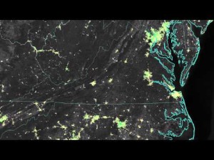
Around many major U.S. cities, nighttime lights shine 20 to 50 percent brighter during Christmas and New Year’s when compared to light output during the rest of the year, as seen in the satellite data. In some Middle Eastern cities, nighttime lights shine more than 50 percent brighter during Ramadan, compared to the rest of the year.

Suomi NPP, a joint NASA/National Oceanic and Atmospheric Administration (NOAA) mission, carries an instrument called the Visible Infrared Imaging Radiometer Suite (VIIRS). VIIRS can observe the dark side of the planet – and detect the glow of lights in cities and towns worldwide. In 2012, NOAA scientists released “Earth at Night” maps, created from VIIRS data. These well-known images are composites – based on monthly long-term averages of data collected on nights with no clouds or moonlight.

The new analysis of holiday lights uses an advanced algorithm, developed atNASA’s Goddard Space Flight Center in Greenbelt, Maryland, that filters out moonlight, clouds and airborne particles in order to isolate city lights on a daily basis. The data from this algorithm provide high-quality satellite information on light output across the globe, allowing scientists to track when – and how brightly – people illuminate the night.

Christmas and New Year’s in the United States

In the United States, the lights started getting brighter on “Black Friday,” the day after Thanksgiving, and continued through New Year’s Day, said Miguel Román, a research physical scientist at NASA Goddard and member of the Suomi NPP Land Discipline Team, who co-led this research. He and his colleagues examined the light output in 2012 and 2013 in 70 U.S. cities, as a first step in determining patterns in urban energy use – a key factor in greenhouse gas emissions.

In most suburbs and outskirts of major cities, light intensity increased by 30 to 50 percent. Lights in the central urban areas did not increase as much as in the suburbs, but still brightened by 20 to 30 percent.

“It’s a near ubiquitous signal. Despite being ethnically and religiously diverse, we found that the U.S. experiences a holiday increase that is present across most urban communities,” Román said. “These lighting patterns are tracking a national shared tradition.”

Because snow reflects so much light, the researchers could only analyze snow-free cities. They focused on the U.S. West Coast from San Francisco and Los Angeles, and cities south of a rough imaginary line from St. Louis to Washington, D.C. The team also examined lighting patterns across 30 major towns in Puerto Rico, known for its vibrant nocturnal celebrations and for having one of the longest Christmas holiday periods.

“Overall, we see less light increases in the dense urban centers, compared to the suburbs and small towns where you have more yard space and single-family homes,” said Eleanor Stokes, a NASA Jenkins Graduate Fellow and Ph.D. candidate at Yale University’s School of Forestry and Environmental Studies, New Haven, Connecticut, who co-led the study with Román.

These new results, illustrating holidays in lights, were presented at the American Geophysical Union’s Fall Meeting in San Francisco.

Ramadan in the Middle East

The idea to look at holiday light-use patterns stemmed from one of the first analyses of the new daily lights algorithm, Román said. Colleagues from NASA Goddard and Yale were looking data of Cairo in 2012 and noticed a large discrepancy.

“‘Either you have something going on with your data that’s wrong, or there’s a real signal there that you have to look into,'” Román recalls them saying. When the team investigated the satellite record, they found that the large increase in light output in Egypt’s capital corresponded with the holy month of Ramadan. During Ramadan, Muslims fast during the day, pushing meals and many social gatherings, markets, commerce and more to nighttime hours.

To confirm that the nighttime signal was not merely an instrument artifact, they examined three consecutive years worth of data from 2012 through the fall of 2014. They found that the peaks in light use closely tracked the Islamic calendar, as Ramadan shifted earlier in the summer.

But not all Middle Eastern cities responded the same as Cairo. Light use in Saudi Arabian cities, such as Riyadh and Jeddah, increased by about 60 to 100 percent through the month of Ramadan. Light use in Turkish cities, however, increased far less. Some regions in Syria, Iraq and Lebanon did not have an increase in light output, or even demonstrated a moderate decrease, possibly due to unstable electrical grids or conflict in the region.

“Even within majority Muslim populations, there are a lot of variations,” Stokes said. “What we’ve seen is that these lighting patterns track cultural variation within the Middle East.”

With the high resolution provided by VIIRS, that variation even appears at the neighborhood level. Román and Stokes used data from Cairo to divide the city’s neighborhoods into different socioeconomic groups, based on available records of voting patterns, access to public sanitation, and literacy rates. Some of the poorest and most devout areas observed Ramadan without significant increases in light use throughout the month, choosing – whether for cultural or financial reasons – to leave their lights off at night. But during the Eid al-Fitr celebration that marks of the end of Ramadan, light use soared across all study groups, as all the neighborhoods appeared to join in the festivities. This is telling researchers that energy is providing services that enable social and cultural activities, Stokes said, and thus energy decision-making patterns are reflecting social and cultural identities.

“Whether you’re rich or poor, or religious or not, everybody in Egypt is celebrating the Eid, or the end of Ramadan,” Román said. This demonstrates that the drivers of demand for energy services aren’t just controlled by individual factors, like price; they are also influenced by the beliefs, statuses, and routines of a city’s inhabitants, he added.

Understanding Energy Decisions

“Having a daily global dynamic dataset of nighttime lights is a new way for researchers to understand the broad societal forces impacting energy decisions,” Stokes said. And with the Intergovernmental Panel on Climate Change noting that greenhouse gas reductions are going to come from energy efficiency and conservation, scientists and policy makers will need to better understand the driving forces behind energy use.

“More than 70 percent of greenhouse gas emissions come from urban areas,” Román said. “If we’re going to reduce these emissions, then we’ll have to do more than just use energy-efficient cars and appliances. We also need to understand how dominant social phenomena, the changing demographics of urban centers, and socio-cultural settings affect energy-use decisions.”

The VIIRS data also provide a new way of looking at how people use cities, from an energy perspective, Román said. Earth-observing satellites like the Landsat series have mapped the footprints and the built infrastructure within urban boundaries for decades – but the presence of buildings doesn’t reveal whether people are actually using them. The new daily dynamic data is a step in that direction, he said.

“What’s really difficult to do is to try and track people’s activity patterns and to understand how this shapes the demand for energy services,” Román said. “We can now see pieces of these patterns from space – when, where and how often we turn on the lights.”

For more information about the Suomi NPP satellite and VIIRS monthly city lights produced at NOAA, visit:

www.nasa.gov/NPP
http://www.ngdc.noaa.gov/eog/viirs.html​

nasa holiday lights

5 Most Haunting Last Photos

Presenting mysterious, haunting and rare final photos from history. From the last photo ever taken of the Titanic to the eerie, tragic end of a scientist caught in a volcanic explosion.

Mysterious, haunting and rare final photos from history. From the last photo ever taken of the Titanic to the eerie, tragic end of a scientist caught in a volcanic explosion.
Find more haunting secrets on Facebook ► http://bit.ly/Dark5FB
Subscribe to Dark5 ► http://bit.ly/dark5

Warning, text spoilers below…
Presenting genuine, strange last photographs from history, including the final picture of the Titanic afloat at sea, a haunting image from American history, the chilling last picture of the Scott Group before being lost forever in Antarctica, the final photo of Machu Picchu’s untouched past and the rare tragic last photograph of volcanologist Daniel Johnston prior to the explosion of Mount St. Helens.

Follow Dark5 on Google+ ► http://bit.ly/Dark5GPlus

Music: “My Impending Doom” by Gracystudios

Intro: “The Machine Thinks”
Background audio copyright Kevin MacLeod (incompetech.com)
Licensed under Creative Commons: By Attribution 3.0
http://creativecommons.org/licenses/b…

dark5 last photos

Red Hot Lava Battles Snow as Volcano Erupts

Volcano observations reveal jets of steam shooting out of the ice and lava moving like a giant caterpillar – although the lava type can make a big difference.

When lava meets snow at the volatile Tolbachik volcano in far eastern Russia, they eject jets of steam as they battle it out. But a look beneath the surface reveals surprising differences in the way the two interact, depending on the type of lava.

Ben Edwards of Dickinson College in Carlisle, Pennsylvania, and colleagues observed lava as the volcano erupted during the winter of 2013. They dug daring observation pits in front of advancing lava flows to identify how it moved through the snow.

As shown in these videos, chunky a’a’ lava advances on top of the rigid snowpack in a rolling caterpillar-like motion, on a layer of melting water. The lava forms a thick tongue that can travel hundreds or thousands of metres.

In contrast, as smoother pahoehoe lava advances, the front of the flow moves under a snowpack, up to 2 metres below the surface. The lava expands beneath the snow, causing steam to shoot up as it mixes with meltwater. It also pushes snow upwards, building snow domes that turn into blocks strewn across the surface as they melt.

The distinctive patterns that result could serve as a fingerprint that identifies where ancient lava has flowed over snow, revealing more about Earth’s climate in the distant past – or even giving clues about the icy, lava-soaked history of Mars.

lava vs snow

How Beretta Shotguns are Made

This video reveals the origin of luxury Beretta shotguns- a poetic journey through sterile robotic rooms is blended with five centuries of Beretta’s history.

Human Technology is an artistic short movie celebrating the uniqueness and the distinction of every Beretta premium gun.

This movie by Ancarani Studio, under the creative direction of Paola Manfrin, reveals through the minutia of the manufacturing process, the genesis of a luxury Beretta shotgun. A poetic journey through sterile robotic rooms is blended with five centuries of Beretta’s history, culminating in the final assembly by the gunsmith, ever the wise guardian of the art of manufacturing.

Learn more on http://HumanTechnology.Beretta.com

Follow Beretta on Facebook: https://www.facebook.com/BerettaItalia
We are also on Twitter: https://twitter.com/BerettaItalia
…and on Instagram: http://instagram.com/berettaitalia

beretta

Boom: North America’s Terrifying Oil-By-Rail Problem

On July 6, 2013, a train hauling two million gallons of crude oil exploded in the Canadian town of Lac-Megantic, killing 47 people.

Boom: North America’s Explosive Oil-By-Rail Problem from Weather Films on Vimeo.

Boom is a terrifying documentary on a problem that you may not be aware of: America has been invaded by hundred of thousands of moving fire bombs—freight trains with old, cheap tanker cars designed to transport corn oil filled with dangerous flammable oil. Logically, accidents are happening, people are dying, and oil is spilling.

As production kept increasing, the oil-by-train transport business grew from 9,500 carloads of crude oil in 2008 to more than 400,000 tankers in 2013, each carrying 30,000 gallons. Many trains carry as much as one hundred cars. Naturally, the list of accidents keeps increasing:

  • A train hauling 2.9 million gallons of Bakken oil derailed and exploded on November 8 in Aliceville, Alabama, and the oil that leaked but did not burn continues to foul the wetlands in the area.
  • On December 30th, a train collision in Casselton, North Dakota 20 miles outside of Fargo, prompted a mass evacuation of over half the town’s residents after 18 cars exploded into fireballs visible for miles. 400,000 gallons of oil spilled after that accident, which involved two trains traveling well below local speed limits.
  • Around 1AM on July 5, 2013, over 60 oil cars exploded after a runaway train derailed in Lac-Megantic, a Canadian town near the Maine border, leveling dozens of buildings and killing 47 of the town’s roughly 6,000 residents.

Sounds bad? It gets worse: The U.S. government says that freight train accidents spilled 1.15 million gallons of crude oil just in 2013. For comparison, the average amount from 1975 to 2012 was 22,000 gallons a year.

According to a New York Times’ story, the bad news don’t stop there: Not only they are putting every city and town with a railroad at risk, we are all paying for it: “States and the federal government have handed out tens of millions in public dollars to rail companies and government agencies to expand crude oil rail transportation across the country.”

500266272_640

Mars’ Gale Crater Once Held Vast Lake

New evidence indicates Mars may have been sufficiently warm and wet to support lakes lasting up to tens of millions of years – enough time for life to form.

Humans have been speculating about water on Mars for hundreds of years, and now thanks to the Curiosity rover we’re getting a better sense of how wet the Red Planet used to be. NASA revealed today that the Gale Crater, the 96-mile wide patch of land Curiosity has been exploring since 2012, held a large lake bed for tens of millions of years. What’s more, the agency found that the three-mile high Mount Sharp, which sits in the middle of the crater, was likely formed by sediment deposits from the lake. The big takeaway? Mars was likely warm enough to house liquid water for long periods of time — perhaps even long enough for life to form. “If our hypothesis for Mount Sharp holds up, it challenges the notion that warm and wet conditions were transient, local or only underground on Mars,” said Ashwin Vasavada, NASA’s Curiosity deputy project scientist. The only problem now is that we still don’t know how the Martian atmosphere supported such a wet environment.

pia19071_gupta-5_delta_cartoon

Curiosity previously found evidence of “vigorous” water flow, which fueled long-held speculation about water’s presence on Mars. NASA is now focusing the rover’s efforts on the lowest layers of Mount Sharp, which could give us a better sense of how it was formed. The findings will also help NASA when planning for future missions to seek out evidence of life on Mars, and potentially even affect how the agency approaches manned missions in the 2030s.

gale crater